Now Reading: Sørvágsvatn and Its Magical Optical Illusion
-
01
Sørvágsvatn and Its Magical Optical Illusion
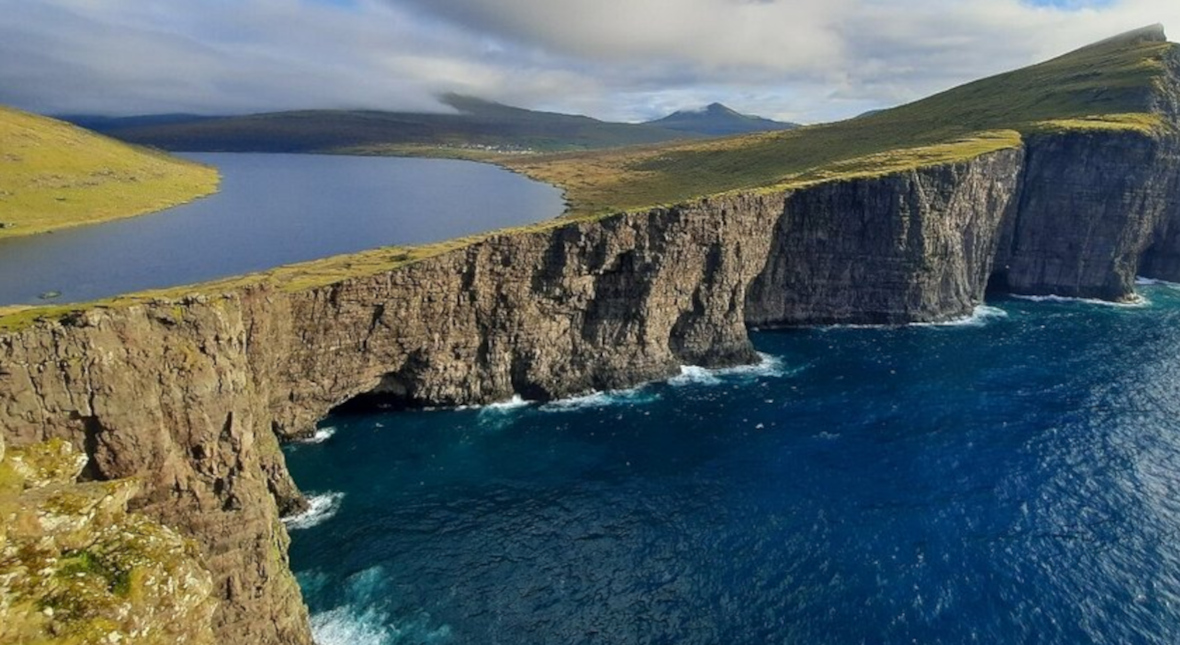
In a remote corner of the North Atlantic, where volcanic cliffs meet restless seas and the wind whispers old Norse tales, lies a lake that plays with your very sense of reality. Sørvágsvatn, the largest lake in the Faroe Islands, is not merely a body of water—it is an optical marvel, a landscape painting brought to life, and a silent testament to nature’s ability to deceive, enchant, and amaze.
From a particular cliffside vantage point, the lake seems to levitate—poised hundreds of feet above the ocean, teetering on the edge of the world. This is no trick of CGI or drone photography. It’s a real phenomenon crafted by perspective, geology, and light. And it is one of the Faroe Islands’ most surreal sights.
A Landscape Built on Illusion
Despite appearances, Sørvágsvatn sits only about 30 meters (98 feet) above sea level. So how can a relatively shallow elevation create the illusion that the lake is perched high above the ocean?
The answer lies in a powerful visual trick that exploits the geometry of the surrounding landscape. When viewed from a specific location on Trælanípa cliff, the gentle slope of the lake’s shoreline aligns perfectly with the steep drop-off of the cliffs in the background. The contrast between the gradual rise of land and the vertical plummet of rock creates the illusion that the lake floats high above the sea.
The phenomenon is similar to forced perspective in photography or film—except here, nature is the director, and the viewer is the unwitting audience.
Sørvágsvatn or Leitisvatn? A Tale of Two Villages
The lake has a dual identity, reflecting a local rivalry between the neighboring villages of Sørvágur and Miðvágur.
Sørvágsvatn means “the lake of Sørvágur.” Residents of this western village claim historical ownership, arguing that the lake once served their pastures and fishing routes.
Leitisvatn, used by those in Miðvágur to the east, translates to “the lake in Leiti”—the name of the area near their village.
This linguistic tug-of-war is more than semantics; it’s rooted in land use, heritage, and pride. While guidebooks tend to use “Sørvágsvatn,” both names remain in active use, reflecting the deeply personal connection locals feel to the land.
Trælanípa: The Slave Cliff’s Dark Legend
Towering near the lake’s edge is Trælanípa, a dramatic cliff face whose name translates to “Slave Cliff.” According to oral legend, during the Viking era, captured thralls or slaves were marched to the edge of this precipice and cast into the sea below if they disobeyed their captors or outlived their usefulness.
While there’s little archaeological evidence to confirm this grim practice, the myth persists, giving the cliff an eerie, solemn quality. Today, it offers not death, but life-affirming vistas: a panoramic sweep of water, stone, sky, and sea that defies expectation.
Hiking Into the Illusion
The journey to Sørvágsvatn is as memorable as the destination. Most travelers begin in the village of Miðvágur, where a well-marked trail leads across open heathland. The hike takes approximately 45 minutes to an hour each way, depending on weather and pace.
As you ascend, the lake gradually reveals itself: a mirror-like sheet of freshwater cradled by rolling grasslands and flanked by basalt cliffs. The trail culminates at Trælanípa, where the optical illusion comes alive. Visitors often stop in stunned silence as the seemingly floating lake stretches out beneath their feet.
A short walk beyond brings you to Bøsdalafossur, the lake’s outlet waterfall. Here, Sørvágsvatn spills into the Atlantic Ocean with elegant force. On windy days, waves crash so violently into the base of the falls that the water is blown backward, as if resisting gravity itself.
Bøsdalafossur: Where Lake Meets Sea
This 30-meter waterfall serves as Sørvágsvatn’s only outlet. Watching freshwater cascade off a cliff and into the ocean is already striking, but Bøsdalafossur holds a further surprise. During powerful Atlantic storms, ocean swells can surge so strongly that they reverse the waterfall’s flow, driving seawater back into the lake in an extraordinary reversal of nature.
This rare phenomenon illustrates the delicate balance between coastal freshwater systems and tidal forces, a dynamic that is particularly vivid in the storm-swept Faroe Islands.
The Best Times to Visit
Sørvágsvatn’s illusion is visible year-round, but seasonal weather can drastically change the hiking conditions and viewing experience.
Spring to Early Autumn (May–September): Ideal for hikers; the path is mostly dry and the visibility is good. The long daylight hours of the Faroese summer allow for extended exploration.
Winter (October–April): Dramatic, moody, and less crowded. However, paths can be muddy or icy, and daylight is limited.


Related Posts
Stay Informed With the Latest & Most Important News
Previous Post
Next Post


Advertisement