Now Reading: The Pamir Plateau: A Scientific Journey to the Roof of the World
-
01
The Pamir Plateau: A Scientific Journey to the Roof of the World
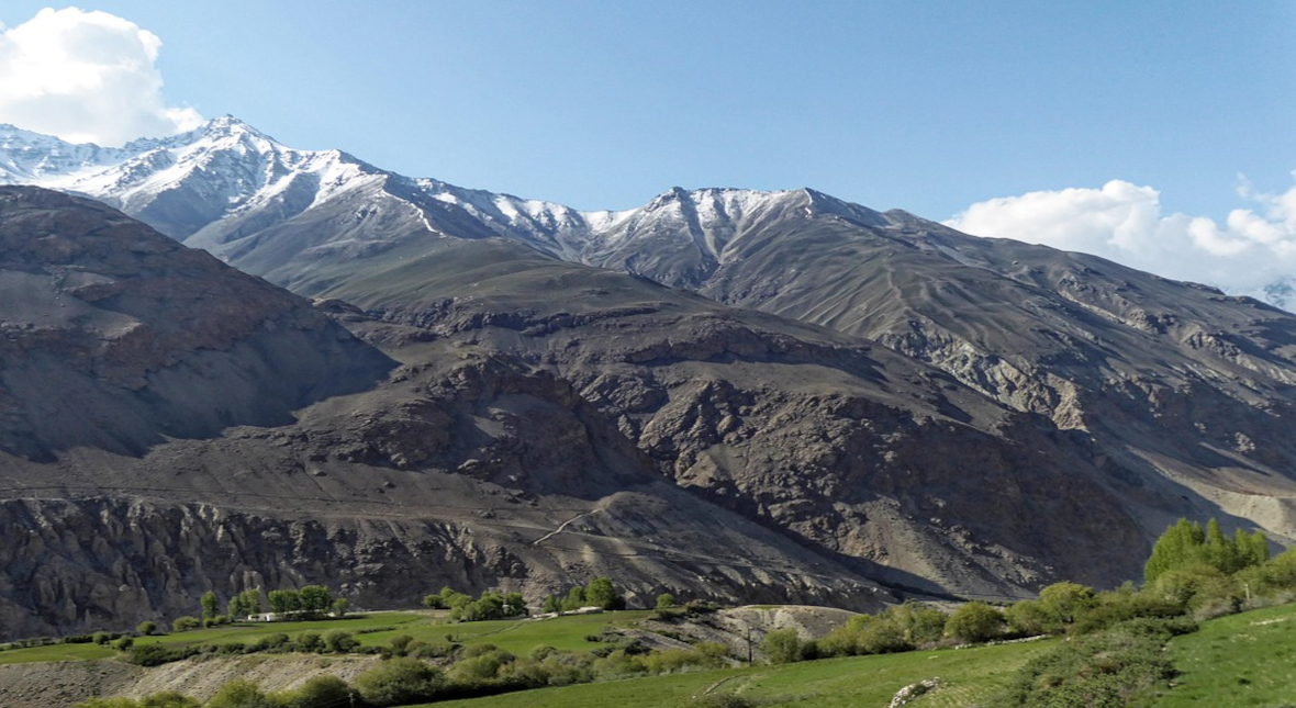
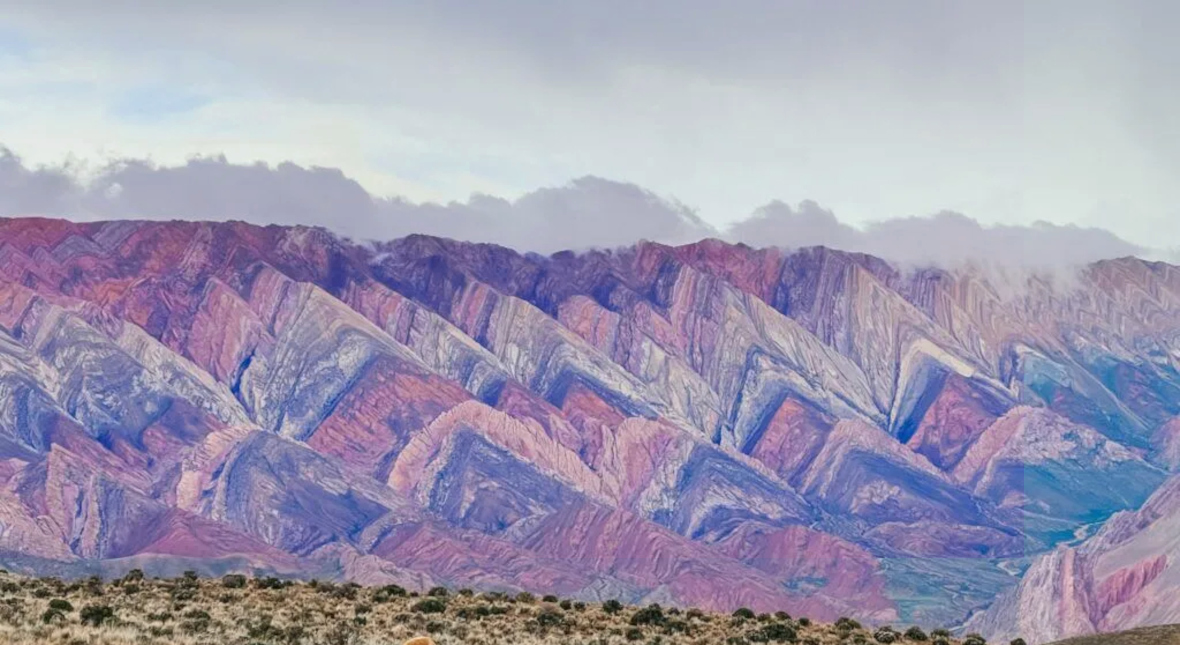
The Pamir Plateau, often referred to as the “Roof of the World,” is one of the most spectacular and remote highland regions on Earth. Rising where the great mountain systems of Asia converge — the Himalayas, Tian Shan, Hindu Kush, and Kunlun — it forms an immense, high-altitude massif that stretches across eastern Tajikistan and spills into China, Afghanistan, and Kyrgyzstan. At altitudes surpassing 3,500 meters and reaching over 7,600 meters at its peaks, the plateau hosts a vast, frozen wilderness of glaciers, barren valleys, and windswept ridges.
But beyond its breathtaking scenery, the Pamir Plateau is a dynamic system — a living, shifting geological engine and an ecological frontier. This is a place where the Earth’s crust thickens and lifts toward the sky, where glaciers feed mighty rivers, and where evolution, climate, and tectonics all collide in real time. From its violent earthquakes to its vanishing glaciers, from its oxygen-thin skies to its endemic species clinging to survival, the Pamirs are more than a remote landscape — they are a scientific observatory, revealing urgent truths about Earth’s past, present, and future.
Tectonic Origins: The Collision That Shaped the Sky
The Pamir Plateau was born from a titanic geological process that continues to reshape it to this day: the collision between the Indian and Eurasian tectonic plates. Around 50 million years ago, the Indian plate began drifting northward, eventually crashing into Eurasia—a process that not only gave rise to the Himalayas but also forced up the Tibetan Plateau and its northwestern extension, the Pamirs. In geological terms, this is a classic example of continental collision, where two buoyant landmasses converge, thickening and warping the Earth’s crust rather than subducting beneath each other.
Today, the Pamirs are among the most tectonically active regions on Earth. The crust beneath the plateau is among the thickest on the planet, in places exceeding 70 kilometers. This crustal thickening results in extreme vertical uplift and a highly dynamic seismic environment. Earthquakes in the region are frequent and often powerful, with both shallow and deep-focus tremors recorded regularly. Major fault systems such as the Sarez–Karakul fault and the Main Pamir Thrust bear witness to this ongoing deformation.
Geologists study the Pamirs using satellite-based tools like Interferometric Synthetic Aperture Radar (InSAR) and Global Positioning System (GPS) arrays to track real-time crustal movements. These data help scientists understand the mechanics of mountain-building, or orogeny, and offer critical clues about earthquake risk not just in Central Asia, but in all tectonically active mountain belts. The Pamir Plateau, then, is more than a landscape—it’s an active, rising frontier of plate tectonics.
Plateau or Mountains? The Structural Puzzle of the Pamirs
Unlike singular mountain chains like the Alps or Andes, the Pamir Plateau is not merely a series of peaks—it is a structural plateau, a raised expanse surrounded and internally dissected by mountain ranges, valleys, and deep tectonic basins. It is characterized by vast, high-elevation plains, interspersed with sharp ridges and glacially carved valleys. Its unique shape has made it a key subject in the study of continental deformation and plateau formation.
This structure is the result of complex forces that include vertical uplift, horizontal compression, lateral extrusion, and crustal thickening. In simpler terms, the rocks beneath the Pamirs have not only been pushed upward but also squeezed and stretched laterally, much like dough in a baker’s hands. These stress fields create a mosaic of fault lines and folds, giving rise to the dramatic relief of the region.
Geological studies suggest that the plateau rose in a relatively short time geologically speaking—perhaps in the last 10 to 15 million years—during a period of accelerated uplift and faulting. Supporting this are marine sedimentary rocks and fossilized marine life found high in the Pamirs, indicating that parts of the plateau were once seafloor. Today, erosion by glaciers and rivers carves down into the uplifted crust, creating the deep valleys that punctuate the high plains.
The Pamirs are thus not just a topographical marvel, but also a textbook case for understanding how continents deform. It challenges scientists to look beyond simple models of uplift and explore the nuanced feedback between tectonics, erosion, and isostasy (the equilibrium between Earth’s crust and mantle).
Glaciers of the Pamirs: Ancient Ice in a Warming World
The Pamirs are home to more than 8,000 glaciers, making them one of the most important glaciated regions outside the polar areas. The largest of these is the Fedchenko Glacier, which stretches over 77 kilometers and contains more than 144 cubic kilometers of ice—comparable in scale to entire icefields in Patagonia or Alaska. These glaciers are critical sources of freshwater, feeding major river systems like the Amu Darya and Panj, and thus indirectly supporting millions of people downstream.
The existence and health of these glaciers are determined by a balance between accumulation (snowfall) and ablation (melting). In the high Pamirs, snowfall is relatively low due to the region’s cold desert climate, meaning that glaciers rely on small annual gains to maintain their mass. However, global warming is tilting this balance. Over the past three decades, satellite observations show that many glaciers in the region have shrunk significantly, with some retreating by more than 30%.
The consequences of this melt extend beyond just local geography. First, the release of glacial meltwater affects hydrological regimes downstream—initially increasing flow but eventually threatening long-term water security. Second, the melting destabilizes slopes, increasing the risk of glacial lake outburst floods (GLOFs), as in the case of Lake Sarez, which has long been a cause of concern due to its massive volume and earthquake-sensitive dam.
Glaciologists use satellite-based laser altimetry, ground-penetrating radar, and climate modeling to monitor the changes. The Pamirs are not just passive ice vaults—they are active participants in the global climate system, and their response to warming will have ripple effects far beyond Central Asia.
Atmospheric Extremes: Cold Deserts in the Sky
The Pamir Plateau experiences one of the most extreme climates on Earth, categorized as a high-altitude cold desert. Its remoteness and elevation (averaging between 3,500 and 4,500 meters) make it a climatic outlier even among mountainous regions. The combination of thin air, low humidity, and limited precipitation results in sharp daily temperature shifts and long, severe winters. Winter temperatures frequently plummet to -30°C or lower, especially in the eastern Pamirs, where the influence of the Siberian anticyclone brings dry, frigid air.
Summer is brief, and while daytime temperatures can climb to 20°C or higher, nights remain cold due to radiative heat loss in the thin atmosphere. Precipitation varies dramatically, with the western Pamirs receiving up to 400 mm annually, while parts of the east get less than 100 mm—comparable to conditions in the Atacama or Gobi deserts. This makes the eastern Pamirs an example of a cold arid zone, with low vegetation cover, high evaporation rates, and fragile soil systems.
From a scientific perspective, the Pamirs are important for studying elevation-dependent warming (EDW)—a phenomenon where temperatures in high mountain regions rise faster than the global average. This is partly due to albedo feedback, as snow and ice melt reveal darker surfaces that absorb more solar radiation. In the Pamirs, such feedback mechanisms are accelerating glacier retreat and altering local microclimates.
Meteorologists and climatologists track the Pamirs through weather stations, reanalysis data, and atmospheric modeling. The region helps scientists refine global circulation models (GCMs) by providing rare data on extreme high-altitude continental interiors. The Pamir climate isn’t just brutal—it’s revealing, offering insight into how mountain systems respond to a warming world.
Permafrost, Soils, and the Hidden Ground Below
Beneath the surface of the Pamirs lies a world that is frozen—literally. Large swaths of the plateau are underlain by discontinuous permafrost, meaning that while some areas are permanently frozen, others thaw and refreeze seasonally. This permafrost plays a critical role in maintaining slope stability, regulating hydrology, and even influencing ecosystems. However, it also makes infrastructure development extraordinarily difficult. Roads, pipelines, and buildings must be designed with thermal stability in mind, lest the thawing ground causes subsidence and collapse.
As the global climate warms, permafrost in the Pamirs is beginning to degrade. Thawing leads to active layer thickening, where the upper soil layer deepens and becomes unstable. This process destabilizes slopes, increases the risk of landslides, and releases trapped greenhouse gases such as methane and carbon dioxide, contributing to a feedback loop of warming. Scientists monitoring permafrost in the Pamirs use boreholes, thermal sensors, and satellite thermal imaging to track these shifts and build predictive thaw models.
Soil in the Pamirs is typically poorly developed due to short growing seasons, slow weathering rates, and limited organic input. Common types include cryosols (frozen soils) and regosols (young, mineral-dominated soils). These are thin, rocky, and nutrient-poor, supporting only the hardiest of plant life such as cushion plants, mosses, and sedges.
Yet even in this challenging environment, soil microbiology thrives, often dominated by cold-adapted bacteria and archaea. These microbes help recycle scarce nutrients and may hold clues for extremophile life on Earth and other planets. The soils of the Pamir Plateau, then, are not just dirt—they are dynamic and sensitive ecosystems that bridge geology, climate, biology, and planetary science.
Water Towers of Asia: Hydrology of the High Plateaus
Despite their aridity, the Pamirs are one of Asia’s most important hydrological headwaters. Often referred to as “water towers,” the high mountains of Central Asia—including the Pamirs, Tien Shan, and Hindu Kush—store vast quantities of water in the form of snow and glacial ice. This frozen reserve gradually melts through the spring and summer, releasing a steady supply of freshwater into the rivers below. The Amu Darya and Panj Rivers, both originating in the Pamirs, irrigate millions of hectares of farmland across Tajikistan, Uzbekistan, and Turkmenistan.
Hydrologically, the Pamirs function as a delayed-release system: snow and ice accumulate in winter, melt slowly during the summer, and sustain river flow even when lower-elevation sources have dried up. This timing is crucial for agriculture, particularly in arid downstream regions that rely on this glacial melt for crop irrigation.
However, this water balance is now under threat. As glaciers shrink and snowpacks decline due to warming, the flow pattern is shifting—initially increasing runoff, but eventually leading to seasonal deficits and drought risk. Hydrologists use stream gauges, glaciological mass balance measurements, and remote sensing (e.g., from GRACE satellites) to assess changes in water storage and discharge patterns.
Moreover, glacial melt is contributing to the formation of unstable proglacial lakes. These lakes, dammed by ice or loose moraines, are prone to sudden collapse, triggering glacial lake outburst floods (GLOFs) that can devastate communities downstream. Lake Sarez, formed by an earthquake-induced landslide in 1911, is one of the largest and most closely monitored.
The hydrology of the Pamir Plateau is not just a regional issue—it’s a transboundary concern involving multiple nations and millions of lives, dependent on a delicate balance of snow, ice, and time.
The Thin Blue Ceiling: Atmospheric Science at High Altitudes
At the lofty heights of the Pamir Plateau, the atmosphere behaves differently from that at sea level. Air pressure drops by nearly 40% at 4,000 meters, meaning that the partial pressure of oxygen is lower, and both humans and ecosystems must adapt to a condition known as hypobaric hypoxia—the body receives less oxygen per breath. For researchers, this makes the Pamirs an ideal natural lab for studying the limits of human and biological endurance.
One of the most striking consequences of high-altitude living is the increase in ultraviolet (UV) radiation. The thin atmosphere filters out less UV, resulting in radiation levels up to 50–60% higher than at sea level. This poses health risks to local populations and travelers, increasing rates of sunburn, eye damage (including snow blindness), and long-term skin issues. However, many Pamiri people have darker skin tones and physiological adaptations—larger lung capacity, higher hemoglobin levels, and improved oxygen diffusion—that offer some protection.
Plants and animals here also exhibit specialized responses. Alpine cushion plants grow close to the ground, minimizing UV exposure and moisture loss, while many insects have evolved UV-reflective or UV-absorbing exoskeletons. Some species produce anthocyanins and flavonoids—natural UV-protectant pigments that may have applications in biotechnology or dermatology.
For climatologists, the Pamirs offer valuable atmospheric data, including measurements of aerosol loading, tropospheric circulation, and ozone concentration. By installing high-altitude weather stations and deploying weather balloons, scientists track not only regional patterns but also global atmospheric phenomena like the Asian Tropopause Aerosol Layer (ATAL), which forms seasonally and affects climate and monsoonal dynamics.
In short, the sky above the Pamirs is as scientifically valuable as the ground below—revealing how life and atmosphere interact at the edge of habitability.
Cold-Blooded Survivors: Ecosystems and Evolution at the Extremes
Despite the harshness of their environment, the Pamirs harbor a surprisingly diverse range of flora and fauna uniquely adapted to life at high altitude. The region’s ecosystems are classified as alpine steppe and cold desert, with plant communities dominated by drought- and frost-tolerant species such as Artemisia (wormwood), Acantholimon, Saxifraga, and various alpine grasses. Vegetation zones shift rapidly with elevation, forming “islands” of biodiversity that vary over short distances due to microclimatic and soil differences.
Animals in the Pamirs are equally remarkable. Among the most iconic species is the Marco Polo sheep (Ovis ammon polii), a high-altitude relative of the argali, distinguished by its massive spiral horns and ability to navigate steep, rocky terrain. Also notable are snow leopards, apex predators adapted to cold, thin air and stealthy ambush hunting; Himalayan ibex, which scale vertical cliffs with ease; and numerous cold-adapted birds like the bearded vulture and Tibetan snowcock.
These species demonstrate adaptive evolution: changes in morphology, physiology, and behavior that have allowed them to thrive in conditions of low oxygen, high UV, and extreme temperatures. For example, many mammals here have dense underfur, large lungs, and increased capillary density, while plants use CAM photosynthesis and deep root systems to conserve water.
Biodiversity is, however, under significant threat. Climate change is shifting ecological zones upward, compressing habitats against mountain peaks with nowhere else to go—a phenomenon called the “escalator to extinction.” Human pressures—such as overgrazing, mining, and unregulated tourism—are fragmenting the already delicate ecosystems. Conservation biologists are working to establish protected areas and wildlife corridors to maintain genetic flow and preserve these unique alpine communities.
Ecologically, the Pamirs offer a window into how life evolves and persists on the fringes of habitability—insights that are valuable not just for Central Asia, but for understanding life in Earth’s changing climate.
Evolutionary Isolation: A Hotspot for High-Altitude Endemism
The Pamir Plateau’s extreme geography—characterized by rugged terrain, deep valleys, and high passes—has created one of the most striking cases of evolutionary isolation in Central Asia. Over thousands of years, populations of plants and animals have become geographically and genetically isolated from one another, fostering the rise of endemic species—those found nowhere else on Earth.
This phenomenon is particularly well documented in alpine plant genera such as Eremogone, Rhodiola, and Draba, which show high levels of speciation. These plants often display distinct morphological traits even between adjacent valleys, shaped by slight differences in altitude, soil pH, exposure to wind, and sunlight. The same applies to insects and small mammals. Some ground beetle species in the Pamirs have ranges restricted to single mountain slopes, making them critically vulnerable to habitat change.
From an evolutionary standpoint, the Pamirs function like sky islands—isolated ecosystems at high elevations that mirror the evolutionary dynamics of oceanic islands like the Galápagos. Here, allopatric speciation (speciation due to geographic separation) is the norm. Because gene flow is restricted by physical barriers like mountain ridges and glaciers, populations diverge rapidly, creating an evolutionary mosaic across the plateau.
These patterns make the Pamirs a fascinating focus for biogeographers and evolutionary geneticists. DNA studies of mountain flora and fauna reveal ancient lineages, some dating back to pre-Ice Age ecosystems, while others indicate recent divergence driven by post-glacial colonization.
Unfortunately, many of these endemic species face extinction risk due to habitat loss, temperature shifts, and competition from invasive species. Their extinction would not only be a loss for regional biodiversity, but also for science—eliminating living records of evolutionary history in one of the most isolated environments on the planet.
A Seismic Laboratory: Earthquakes and Crustal Dynamics in the Pamirs
Few places on Earth reveal the raw dynamics of tectonic motion as clearly as the Pamir Plateau. Wedged between several major fault systems, the region experiences regular and often powerful earthquakes as a direct result of crustal shortening, thrusting, and subduction-like underplating. Unlike oceanic subduction zones, where one tectonic plate dives beneath another, the Pamirs feature continental subduction, where portions of thickened continental crust descend beneath the overlying lithosphere.
Major fault zones, such as the Pamir Frontal Thrust and Sarez–Karakul Fault System, accommodate much of the tectonic strain. These faults are responsible for both shallow crustal quakes and deeper mantle events, making the region a seismological curiosity. The devastating 1911 Sarez earthquake (M 7.4), which created the infamous Usoi Dam and formed Lake Sarez, illustrates the power of this tectonic setting. The 600-meter-high natural dam, made of landslide debris, remains structurally unstable and under constant monitoring due to its catastrophic flood potential.
Seismologists employ dense seismic arrays, broadband sensors, and InSAR (Interferometric Synthetic Aperture Radar) to monitor crustal deformation and detect hidden fault slip. The data provide crucial insights into stress accumulation, rupture dynamics, and the distribution of seismic energy across active mountain belts. New advances in seismic tomography even allow imaging of the lithospheric root beneath the Pamirs, where cold, dense crust sinks into the mantle—an analog to much larger-scale subduction processes found at ocean margins.
Understanding seismic hazards in the Pamirs is more than academic. Tens of thousands of people live in seismically vulnerable valleys, and future earthquakes could trigger massive landslides or glacial lake outbursts. Thus, the Pamirs serve not only as a natural experiment in continental tectonics, but also as a critical zone for developing earthquake early-warning systems and disaster resilience strategies.
Dust, Albedo, and the Cryosphere Feedback Loop
The glaciers of the Pamirs are more than just frozen reservoirs—they are sensitive participants in a complex system of energy exchange, and recent findings show that atmospheric dust plays a pivotal role in accelerating their decline. Dust blown in from surrounding deserts, especially the Taklamakan Desert to the east and the Afghan highlands to the south, settles onto snow and ice surfaces, dramatically altering their albedo—the reflectivity of the surface.
Fresh snow has a high albedo, reflecting up to 90% of incoming solar radiation. But when dust or soot particles darken that surface, albedo can drop to 40% or less, allowing more solar energy to be absorbed. This extra heat accelerates surface melt, exposing deeper, older ice layers that may contain more impurities, further reducing albedo. The cycle feeds on itself, forming a positive feedback loop known as the snow-darkening effect.
This effect is now well-documented using remote sensing tools like NASA’s MODIS satellites and the European Space Agency’s Sentinel-2, which monitor snow cover, dust deposition, and surface reflectivity. Ground-based field studies complement satellite data by analyzing dust composition—much of which includes fine silicates, carbonaceous material, and even anthropogenic pollutants.
The implications are far-reaching. Not only do darker snowfields melt faster, but the meltwater quality is also affected—dust-laden snow introduces minerals and heavy metals into glacial streams. Furthermore, as glaciers retreat, exposed moraines and bare soil increase local dust emissions, reinforcing the same cycle that caused the retreat.
The Pamirs, then, offer a live demonstration of how small changes in surface properties can lead to large-scale environmental transformations. Studying these feedback mechanisms helps scientists predict glacier responses in other parts of the world, including the Arctic and Himalayas, where dust and soot from industrial regions are having similar effects.
A Sentinel for Global Change: Climate Science in the Pamirs
Perhaps the most sobering truth about the Pamir Plateau is that it is warming faster than the global average. This phenomenon, known as elevation-dependent warming (EDW), is increasingly evident across all of Central Asia’s mountain systems. In the Pamirs, average temperatures have risen by nearly 1.5°C since the mid-20th century, with projections indicating a possible additional rise of 3–5°C by the end of the century if emissions remain unchecked.
The implications are enormous. Glaciers that have taken millennia to form may vanish in just decades. Snowlines are retreating upward, and permafrost is thawing at unprecedented rates. River flow regimes are changing, with peak runoff arriving earlier in the year—bad news for agriculture downstream that relies on sustained summer melt. Native plant and animal species are being pushed into smaller, shrinking ecological niches. These are not hypothetical futures—they are measurable trends occurring now.
Scientists are using the Pamirs to model tipping points in Earth’s climate systems. These mountains offer a “fast-forward” preview of what could happen elsewhere as warming intensifies. Researchers study how the loss of ice and snow cover changes regional heat budgets, alters air circulation, and even impacts monsoonal precipitation patterns. In a broader sense, the Pamirs serve as a climate observatory, where the interconnections between atmosphere, cryosphere, biosphere, and lithosphere are all visible at once.
International collaborations like the Third Pole Environment Program (TPE) and Global Cryosphere Watch increasingly focus on the Pamirs as part of a broader effort to understand high-mountain Asia. These programs integrate climate modeling, field observation, and community-based adaptation to tackle the urgent challenges facing both nature and people.
Ultimately, the Pamir Plateau is more than a roof of the world—it is a sentinel, sounding the alarm for a planet in transition. If we want to understand and adapt to climate change, we must listen to what these silent, icy peaks are telling us.


Related Posts
Stay Informed With the Latest & Most Important News
Previous Post
Next Post


Advertisement