Now Reading: Water in the Desert: Analysis of the Hydraulic Systems at Petra and Hegra
-
01
Water in the Desert: Analysis of the Hydraulic Systems at Petra and Hegra
Water in the Desert: Analysis of the Hydraulic Systems at Petra and Hegra
No achievement of the Nabataeans was more decisive than their mastery of water. In landscapes defined by scarcity, unpredictability, and climatic extremes, water was not merely a resource—it was the foundation of political authority, economic stability, and urban permanence. Without advanced hydraulic engineering, neither Petra nor Hegra could have functioned as thriving centers of trade, religious activity, or administrative governance.
The Nabataeans did not inherit great rivers like the Nile or Euphrates. Nor did they build settlements in fertile river valleys where water was abundant and predictable. Instead, they engineered their own hydrological realities. They captured seasonal rainfall, tamed flash floods, extracted groundwater from uncertain aquifers, stored it safely, and distributed it efficiently to support dense populations, agriculture, and ceremonial life. Their approach was neither improvised nor haphazard; it was systematic, observational, and continuously refined over generations, demonstrating a profound understanding of geology, climatology, and fluid dynamics.
Petra and Hegra represent two distinct hydraulic strategies shaped by environment. Petra, carved into the dramatic sandstone canyons, required large-scale urban flood management and integrated water distribution networks. Hegra, set in a flat desert plain, depended on sustainable groundwater extraction and decentralized storage, tailored for a frontier settlement subject to unpredictable aquifer recharge. A comparative study of these two sites illuminates the flexibility, adaptability, and technical sophistication of Nabataean engineers and offers insights into how human ingenuity can transform some of the harshest deserts into habitable and thriving urban centers.
Comparative Hydraulic Efficiency
| Feature | Petra | Hegra |
|---|---|---|
| System Scale | Macro-urban, city-wide | Micro, modular |
| Primary Water Source | Springs, runoff, minor wells | Wells (groundwater) |
| Storage Volume | 500–600 m³ per cistern | 40–50 m³ per cistern |
| Flood Control | Large dams, diversion channels | Small protective barriers |
| Channel Complexity | Long, plastered, ceramic-lined | Short, simple, local |
| Maintenance Requirement | Centralized, high labor demand | Localized, moderate labor |
| Resilience Strategy | Abundance via storage | Redundancy via decentralization |
Environmental Conditions and Hydrological Reality
Petra: Flash Flood Basin Engineering
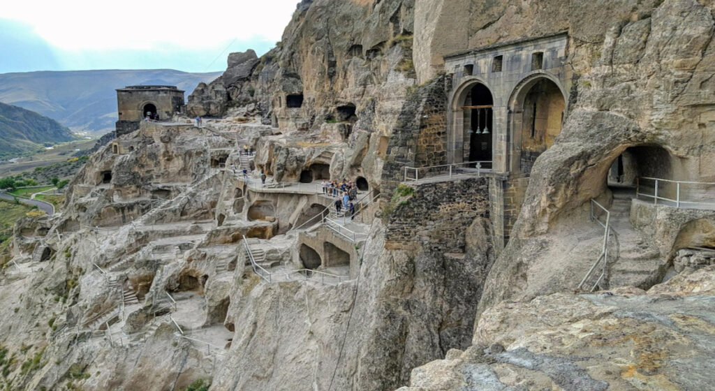
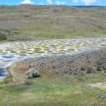
Petra sits in a mountainous basin characterized by steep slopes and narrow gorges, known as wadis, which channel stormwater with immense force. Rainfall is sporadic yet intense, often concentrated in brief but violent thunderstorms. When rain falls, torrents surge through constricted passages like the Siq, capable of carrying boulders, sediment, and debris with enough kinetic energy to demolish any unprotected structure.
This created a complex engineering paradox: the city needed to maximize water capture during rare rainfall events while simultaneously preventing catastrophic flooding. Nabataean engineers approached this challenge scientifically. They mapped the catchment areas, observed seasonal flow patterns, studied slope gradients, and predicted flood behavior. Their solution was not mere reaction; they actively reshaped hydrological dynamics, constructing diversion channels, dams, and storage systems that transformed dangerous flash floods into controlled water resources.
The environmental context also demanded attention to sediment transport. Flash floods carried fine sand and coarse gravel, which could quickly clog channels or damage dams. Engineers integrated sediment collection basins, settling tanks, and graded channels to maintain the functionality of water networks. This demonstrates advanced understanding of fluid mechanics long before such principles were formally studied in classical science.
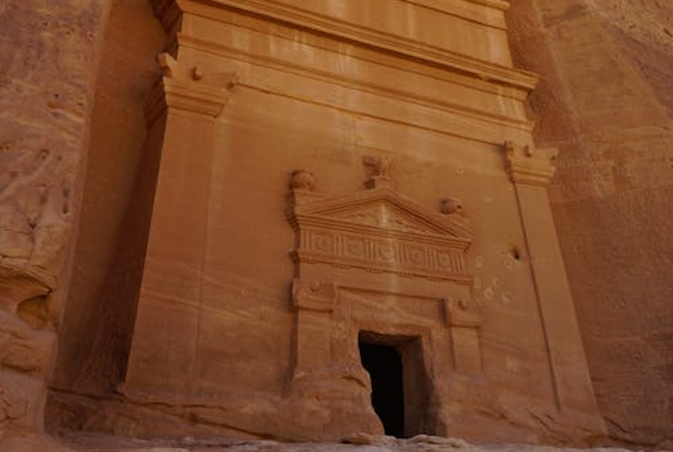
Hegra: Desert Plain and Aquifer Dependency
Hegra presents a starkly different challenge. Situated on a broad sandstone plain, it lacks the natural gorges that channel concentrated runoff. Rainfall is lower, sporadic, and dispersed, meaning surface water alone could not sustain permanent settlement.
Here, Nabataean engineers relied on vertical hydraulic solutions, primarily wells accessing shallow aquifers replenished intermittently by infiltration through porous sandstone. Wells had to be deep enough to reach reliable water tables, but shallow enough to remain maintainable and resistant to collapse. Engineers also needed to prevent sand intrusion and ensure year-round access, sometimes requiring stone linings and pulley-based extraction systems.
Petra and Hegra thus illustrate contrasting environmental strategies: Petra manipulated water horizontally across the landscape, controlling flow, storage, and sediment; Hegra extracted water vertically, stabilizing it for distributed consumption.
Petra: Flood Diversion and Structural Loads
Petra’s large dams, such as those at the entrance of the Siq, were engineered to withstand dynamic flood forces. Conceptually, the hydrostatic pressure exerted on a dam can be expressed as:
P=ρ⋅g⋅HP = \rho \cdot g \cdot H
Where:
-
ρ\rho = 1000 kg/m³ (density of water)
-
gg = 9.81 m/s² (gravitational acceleration)
-
HH = maximum water depth (~3–5 m for most dams)
Thus, lateral pressure at the base of the dam reaches approximately 30–50 kPa. To resist bending and shear, Nabataean engineers used thick masonry walls (0.5–1 m) and embedded abutments into the canyon walls to transfer forces directly to stable rock strata.
The dam cross-section was likely trapezoidal to distribute compressive stress and resist overturning. The factor of safety was conceptually high, given uncertainty in peak flood volumes during desert storms. The combination of stone blocks and hydraulic plaster provided both structural stability and impermeability.
Hegra: Micro-Barriers and Well Protection
Hegra’s hydraulic engineering focused on localized sediment and flood protection. Retaining walls surrounding cisterns or well heads were comparatively small—1–2 m high—but designed to resist lateral pressure from sand, loose gravel, and limited seasonal runoff.
Using Rankine lateral earth pressure theory, lateral force qq can be estimated:
q=K⋅γ⋅Hq = K \cdot \gamma \cdot H
Where:
-
KK = 0.3–0.5 (coefficient for dry sandy soils)
-
γ\gamma ≈ 18 kN/m³ (unit weight of sand)
-
HH ≈ 2 m
This yields lateral pressure q≈10–20kPaq ≈ 10–20 kPa, well within the strength capacity of stone masonry. Such micro-engineering ensured that the system remained stable under moderate environmental stress.
Dam Construction and Flood Control at Petra
One of Petra’s most striking hydraulic features is its dam system at the Siq entrance, a narrow canyon forming the main approach to the city. Seasonal floods without intervention could have obliterated urban infrastructure and cut off access for merchants, pilgrims, and administrators.
The Nabataeans built masonry dams reinforced with abutments embedded into canyon walls, spillways to control overflow, and diversion tunnels cut through solid rock to redirect excessive water. Upstream, sediment collection basins protected reservoirs from silting. Hydraulic plaster—a lime-based, waterproof mortar—coated dams to prevent leakage and structural erosion. Its successful application required precise understanding of chemical composition, curing methods, and thermal expansion of materials.
These dams did not eliminate floods; they channeled, slowed, and stored water, turning a natural threat into a resource. The scale and sophistication contrast with Hegra, where no macro-dams were necessary, reflecting adaptation to localized environmental pressures rather than the grandeur of urban ambition.
Channel Systems and Flow Regulation
Petra’s Integrated Channel Network
Petra’s channel network is a masterclass in hydrological planning. Channels carved into sandstone cliffs transported water from springs and runoff collection points to cisterns and reservoirs. Advanced features included:
Ceramic pipes fitted into carved rock grooves
Socket joints sealed with mortar to prevent leakage
Protective slabs reducing evaporation and contamination
Settling basins to trap sediment before it reached storage
Gradient calculation was critical. Too steep a slope caused erosion; too shallow led to stagnation. The system ensured continuous gravity-fed flow, enabling water distribution for domestic use, irrigation, and ceremonial functions. The network formed a unified hydraulic grid, a precursor to modern municipal water systems.
Hegra’s Localized Conveyance
Hegra’s channels were shorter, simpler, and pragmatic, directing surface runoff into nearby cisterns. Without springs or concentrated flows, long-distance channels were unnecessary. Wells provided primary supply, and small conduits ensured efficient local distribution to residential clusters. The simplicity of design reflects optimized function over scale, demonstrating that engineering sophistication can coexist with minimalist construction.
Gravity-Flow Channel Engineering
Petra: Precision Gradient Control
Petra’s channels employed gravity-fed flow, requiring careful slope calculation. Conceptually, flow velocity vv can be estimated via the Manning equation:
v=1nR2/3S1/2v = \frac{1}{n} R^{2/3} S^{1/2}
Where:
-
nn ≈ 0.013–0.015 (channel roughness for plastered stone)
-
RR = hydraulic radius (area/wetted perimeter)
-
SS = slope (~0.005–0.01)
Flow rates were calibrated to avoid erosion while ensuring water reached cisterns and terraces. Settling basins and minor bends in the channel dissipated energy and allowed sediment deposition, reducing abrasive damage.
Hegra: Short-Distance Conduits
Hegra relied primarily on short surface channels and well-fed cisterns. Gravity gradients were minimal (~0.002–0.005), and velocity was low, minimizing erosion. Water conveyance was mostly local and vertical, reducing the need for long, complex channel networks.
Cisterns and Storage Engineering
Petra: Monumental Reservoirs
Petra’s cisterns were massive underground chambers carved into bedrock, plaster-lined to prevent seepage. They could sustain tens of thousands of residents through prolonged dry periods. Excavation demanded coordinated labor, precise cutting, and knowledge of structural stresses, while plaster preparation required chemical expertise and ongoing maintenance. Reservoirs also supported agricultural terraces and ornamental gardens, enhancing urban life despite the harsh climate.
Hegra: Distributed Storage
Hegra adopted a decentralized cistern strategy, with small reservoirs located near tomb clusters or residential zones. This minimized risk: if one cistern failed or became contaminated, others could supply water. The approach emphasized resilience over abundance, reflecting practical adaptation for a frontier settlement with fluctuating populations and sporadic rainfall.
Cistern Design and Hydrostatic Load
Petra: Monumental Underground Storage
Petra’s cisterns, often 5–6 m deep with volumes exceeding 500 m³, were carved directly into bedrock. Hydrostatic pressure at the base is calculated:
P=ρgH≈49kPaP = \rho g H \approx 49 kPa
Walls and ceilings were designed to resist lateral pressure from stored water and overlying rock. Hydraulic plaster lining served dual purposes:
-
Seepage prevention: Retaining nearly 100% of stored water
-
Structural reinforcement: Distributing load and reducing stress concentration
Excavation sequence likely began at the top of the chamber to minimize debris accumulation and structural failure risk.
Hegra: Decentralized Storage Chambers
Cisterns at Hegra were smaller (≈3–4 m deep, 40–50 m³ volume). Hydrostatic pressure was correspondingly lower (~30 kPa), reducing structural demands. Distributed cisterns ensured redundancy: if one failed, others maintained water supply, reflecting modular engineering resilience.
Well Engineering and Aquifer Access at Hegra
Wells were the backbone of Hegra’s water system:
Vertical shafts excavated through sediment and sandstone
Stone linings stabilized loose material and prevented collapse
Pulley systems likely facilitated water extraction
Continuous maintenance prevented sand infiltration and ensured year-round access
Petra relied on wells sparingly, demonstrating that hydraulic strategy depended on environmental context rather than technical capacity.
Well Mechanics and Vertical Excavation
Hegra’s reliance on vertical wells required understanding of lateral soil pressure, groundwater fluctuations, and safe shaft diameter. Lining shafts with stone prevented collapse. Conceptually, lateral earth pressure increases with depth:
q=K⋅γ⋅Hq = K \cdot \gamma \cdot H
With H ≈ 10–12 m, pressures could reach ~70 kPa. Stone lining plus a slight batter provided stability. Pulley systems or manual bucket lifts facilitated water extraction.
Petra, in contrast, used wells minimally; surface water predominated.
Maintenance and Institutional Organization
Both cities required ongoing labor for system functionality. Sediment removal, plaster repair, structural reinforcement, and well cleaning were essential.
Petra’s centralized infrastructure required trained engineers, oversight, and coordinated labor, possibly supported by a bureaucratic administration.
Hegra’s smaller-scale networks allowed community-level maintenance, reflecting social organization that paired technical responsibility with settlement scale.
Urban Planning and Hydraulic Influence
Hydraulics shaped the urban identity of these cities:
Petra: Buildings, streets, and terraces aligned with water supply; infrastructure was monumental, visible, and integrated into daily life.
Hegra: Settlements clustered near wells; hydraulic structures were discreet, functional, and supportive rather than defining the city’s visual character.
Roman Annexation and Hydraulic Continuity
Rome annexed the Nabataean kingdom in 106 CE. Despite their aqueduct-based engineering expertise, Romans largely retained existing Nabataean methods, recognizing their efficiency:
Petra continued to function under Roman oversight, trade routes gradually shifting to maritime channels
Hegra’s wells and cisterns remained effective, maintained with minor improvements
Hydraulic continuity underscores the technical sufficiency, environmental appropriateness, and enduring relevance of Nabataean engineering.
Comparative Resilience and Sustainability
Petra: Centralized, high-capacity, maintenance-intensive. Dam or reservoir failure could be catastrophic.
Hegra: Decentralized, flexible, lower-efficiency, highly resilient. Failure of one component did not endanger settlement survival.
The contrast reflects centralized vs modular resilience, showing how human societies tailor infrastructure to environmental risk and resource availability.
Engineering Legacy
The hydraulic systems of Petra and Hegra demonstrate exceptional environmental intelligence, technological skill, and societal organization. Nabataeans:
Observed and interpreted hydrological patterns
Mastered stone, mortar, and plaster technologies
Applied gravity-fed flow principles
Developed institutional capacity for maintenance
Petra exemplifies grand urban hydraulic integration, Hegra pragmatic desert adaptation. Together, they prove that Nabataeans were more than artisans or traders—they were visionary engineers transforming deserts into sustainable cultural hubs.


Related Posts
Stay Informed With the Latest & Most Important News
Previous Post
Next Post


Advertisement